
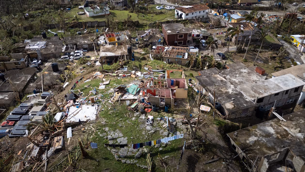
Natural disasters can destroy entire communities in a matter of minutes, damaging homes and buildings, creating impassable roads, and cutting off neighborhoods from the help they need. When a disaster strikes, insurance providers must have the means to document the affected areas so they can evaluate claims and support policyholders in the recovery process.
Aerial operations allow insurance adjusters to soar high above the chaos, moving quickly to capture detailed data without putting themselves at risk. Whether transporting personnel directly to disaster sites or using advanced technology to assess major structural damage, helicopters play a critical role in providing a quick and efficient crisis response.
Below, you’ll discover how helicopters support insurance companies, the technology that makes flight-based surveys so effective, and how specialized aviation teams help insurers accelerate claim processing after large-scale emergencies.
How Helicopter Services Enhance Post-Disaster Claim Assessments
Helicopters give insurers a faster, safer way to survey disaster impact. They help streamline the entire claim process by providing:
Access to Hard-to-Reach Areas
After hurricanes, floods, wildfires, or earthquakes, roads are often collapsed or blocked by debris. Rotorcraft enable inspectors to fly overhead, avoiding the damaged roads and infrastructure that prevent ground-based adjusters from accessing impacted communities.
Helicopters are particularly helpful for accessing:
Flooded neighborhoods
- Isolated rural communities
- Mountainous or heavily wooded regions
- Urban areas with major infrastructure issues
While ground vehicles may be delayed for days or even weeks as access is restored, helicopters enable near-immediate documentation.
Detailed Data
Airborne platforms support advanced technology capable of capturing detailed property data. This visual evidence helps adjusters analyze the structural impact of disasters on a wider scale without waiting for ground-based inspectors to access individual properties.
Helicopter-based imaging can provide:
- Clear overhead imagery that identifies roof destruction and debris
- Thermal and 3D mapping data that reveals hidden structural issues
- Geotagged visuals that connect every property to a specific location
This visual data boosts claim accuracy and reduces the need for multiple site visits.
Safer Surveys
Aerial assessments help prevent insurance adjusters from needing to enter disaster-stricken areas that pose risks such as:
- Structural collapse
- Exposed utilities
- Contaminated floodwater
- Hazardous debris
Insurance teams can maintain productivity during high-pressure disaster response situations without physically navigating damaged structures and unstable ground.
Quicker Evaluations and Claim Processing
Helicopter surveys accelerate catastrophe claims through:
- Rapid Site Access: When roads are blocked or unsafe, helicopters can transport insurers directly to affected sites.
- Fast Data Delivery: Specialized technology uploads imagery quickly so claims move through the review process without delay.
- Time-Stamped Visual Records: Aerial imagery creates detailed records that adjusters can compare to pre-loss conditions. During large-scale disasters, these records enable insurers to process multiple filings at once, accelerating decisions and payouts.
Expansive Evaluations
Natural disasters like hurricanes or tornadoes can impact hundreds or even thousands of properties across widespread regions. Helicopters are critical for conducting broad reconnaissance of disaster zones so insurers can quickly pinpoint:
- Concentrated impact zones that require immediate prioritization
- Flood boundaries
- Debris fields
- Accessibility barriers for ground-based vehicles
Wide-scale surveys conducted from an overhead vantage point enable allocation of resources toward the highest-severity losses first, while reviews of multiple properties in a single trip allow multiple claims to be processed at the same time.
Heavy-Lift Support
Some missions require more than small cameras or videos for the most efficient and precise data. Heavy-lift aircraft, like the fleet from Helicopter Express, are capable of transporting:
- Specialized imaging equipment and technology
- Entire damage survey teams
- Heavy emergency response supplies
By combining speed, safety, and precision, helicopter operations help insurers respond efficiently when timely claim analysis matters most.
Aerial Insurance Claim Assessments: How the Process Works
Flight-based insurance claim assessments follow a structured, multi-step process that delivers fast, accurate evaluations after major disasters.
Step 1: Coordination of Responsibilities
Far-reaching emergencies require quick response times and seamless coordination between insurance companies, aviation teams, dispatch, and field adjusters. Many insurers follow an incident-management approach that includes:
- Clear designation of roles and responsibilities (including tactical resource management, property prioritization, logistics coordination, and safety protocols)
- Scheduled status checks
- Close communication with all emergency response partners
Discover key systems and strategies for coordinating multi-helicopter emergency response.
Step 2: Strategic Flight Planning
Before an aircraft deploys, insurance companies and their helicopter partners must map detailed mission plans that account for:
- Operation type
- Flight routes and airspace restrictions
- Fuel logistics and landing zones
- Communication systems and protocols
- Current and projected weather conditions
- GPS and GIS mapping
This planning is important because natural disasters often create smoke, wind, and debris that can impact safe flight.
Step 3: Safety Protocols
Helicopter crisis response crews follow strict safety protocols to protect crew members and communities.
These safety measures often include:
- Landing zone preparation
- Safety briefings
- Standardized communication procedures
- Continuous weather tracking
- Crew fatigue management
Step 4: Prioritized Property Surveys
Not all claims require immediate inspection. Because helicopter rentals can be expensive, insurers generally hire flight teams for inaccessible areas that have experienced major catastrophes.
High-priority targets typically include:
- Collapsed roofs and severe structural damage
- Major flood zones
- Commercial property losses
- Areas where ground access is blocked
By narrowing the workload and limiting overhead inspections to the most severely impacted regions, insurers can save money while improving claim processing times.
Step 5: Aerial Imaging Flights
Next, pilots and flight crews follow their planned flight paths to capture high-resolution photos and videos of impacted communities.
This technology helps:
- Identify individual property losses
- Document widespread patterns
- Locate debris
Insurance adjusters use these timestamped visual records to process filings more efficiently.

Step 6: Rapid Data Transfer
Images, videos, and 3D mapping are quickly transmitted to claim adjustment teams so they can:
- Verify reports
- Determine claim severity
- Identify properties requiring on-site inspection
- Estimate repair costs
Technology That Powers Aerial Damage Surveys
Advanced imaging and mapping systems are critical for capturing and documenting the impact of natural disasters. Cameras and video, GPS and GIS systems, LiDAR, and analytics software all improve the quality and usability of aerial data.
High-Resolution Imaging
Cameras and video systems are the most common tools insurance companies use to evaluate claims after a catastrophe. Despite their affordability, these systems produce broad imagery that captures fine details regarding:
- Affected neighborhoods and commercial buildings
- Impacted rooftops
- Flood zones
- Wildfire spread
- Debris fields
This wide-area imaging supports assessments of both individual properties and entire communities.

GPS and GIS Systems
Helicopters use a satellite-based Global Positioning System, or GPS, to capture real-time positioning insights. GPS works by picking up signals from a network of satellites that orbit the Earth, calculating its exact position in latitude, longitude, and altitude.
GPS integrates with the Geographic Information System, or GIS, which analyzes and displays geographically referenced information associated with a unique location. These technology systems work even in regions where ground-based navigational aids are not an option due to expansive destruction, such as:
- Remote areas
- Over open water
- In dense urban environments
After a natural disaster strikes, GPS and GIS layers provide insurers with location intelligence that associates each image with a specific property. This allows adjusters to prioritize reviewing the most significant losses first.
According to the U.S. government, GPS signals offer guaranteed accuracy to within 6.6 feet at least 95% of the time across all active satellites. In practice, the actual margin of error is typically less than 2.1 feet 95% of the time.
Learn more about the role of advanced navigation systems in modern helicopter operations.
LiDAR Technology
Light Detection and Ranging (LiDAR) technology is a highly accurate solution for creating detailed maps of the environment below.
Here’s how it works:
- Once mounted on a helicopter, LiDAR emits laser pulses.
- After coming into contact with different objects, it measures how long it takes for the lasers to bounce back.
- These measurements capture data about the structure and shape of surrounding landscapes.
- Next, they are processed to create precise, high-resolution 3D maps depicting elements like terrain, buildings, and vegetation—even those not visible to the naked eye.
After a natural disaster, helicopter-based LiDAR can build 3D models of the post-disaster landscape below. It can also measure structural conditions to help insurance companies assess damage rapidly and accurately. In fact, recent advances in certain types of LiDAR can measure velocity to within 0.8 centimeters per second and pinpoint locations to within 0.8 meters.
Analytics Software and AI
Insurance companies can pair the detailed maps and images captured by technology like LiDAR with analytics systems and artificial intelligence (AI) to enable:
- Quicker assessments with reduced manual processing time
- Detection of patterns and recurring destruction across specific regions
- Effective pre-loss and post-loss condition comparisons
- Fraud detection support
All of these systems contribute to the evidence insurance adjusters need to accurately prioritize and verify claims, make estimates, and protect against fraud.
Helicopter Express: Your Trusted Partner for Disaster-Related Insurance Claims
Based in North Georgia, Helicopter Express provides heavy-lift and emergency helicopter services to support insurance carriers, disaster response agencies, and other organizations after significant disasters in the U.S. and abroad.
Our modern fleet and experienced crews assist post-disaster insurance operations through:
- Aerial Surveys: You can trust our skilled pilots to conduct safe, low-altitude flights that capture the detailed imagery and mapping data needed for accurate claim decisions.
- Heavy-Lift Transport: Our heavy-lift rotorcraft are capable of transporting entire teams, specialized equipment, and essential cargo to disaster zones.
- Crisis Response Coordination: We provide dedicated flight coordinators who are committed to delivering rapid, reliable assistance when it matters most. Our staff works hard to handle emergency requests, coordinate with relevant agencies, and provide real-time crew support.
When faced with a critical situation, you need a partner you can trust. For over two decades, the team at Helicopter Express has navigated challenging disaster response missions while adhering to the highest safety standards.
Ready to Get Started?
Contact us to learn how our dependable aviation services align with your rapid claim response goals. Our skilled pilots and dedicated flight coordinators will ensure you receive the heavy-lift capability and thorough documentation you need.